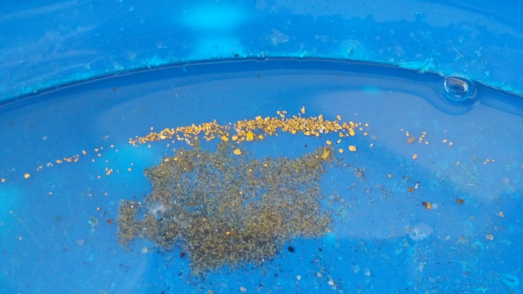
Golden Rock Cr. 6
This amazing unpatented mining claim on Rock Creek, is positioned right below the Golden Cycle Mine. Rock Creek has a collection of rich deposits downstream of the historic Sloper Mine, Golden Chariot Mine, Golden Cycle Mine in Boise County, as well as other shafts located on the Burns Ridge line (see link below for the Geological Survey report for these mines… pgs 248 to 250). The campsite down at the switchback is, suitable for a trailer, with ample year round water across the claim. Incredible scenery, lots of trails and ATV roads, and the Kirkham hot springs 14 miles down HWY 21, for all kinds of recreational enjoyment nearby. Full services in Idaho City 31 miles south, or Lowman 10 miles to the north of the mining claim.
- Acreage: 20 acres
- River footage: 1400’ of Rock Creek
- Placer/lode: placer
- Location: Boise County, Twn. 8N, Rng. 7E, Sec 17, NE ¼
- Mining claim serial #: IMC 215747
Map to Claim
Coordinates
NW 44°02’13.9236″N, -115°38’57.1956″W
NE 44°02’13.9236″N, -115°38’47.4396″W
SE 44°02’00.4236″N, -115°38’47.4396″W
SW 44°02’00.4236″N, -115°38’57.1956″W
NW 44.037201°N, -115.649221°W
NE 44.037201°N, -115.646511°W
SE 44.033451°N, -115.646511°W
SW 44.033451°N, -115.649221°W
Maps


Images


Overview
Geological Report:
https://pubs.usgs.gov/bul/0944c/report.pdf
Driving Directions: The claim is located 24 miles outside the historic town of Idaho City. Driving directions to the claim: from I-84 in Boise, you will take exit 57 travel northeast on HWY 21. Stay on HWY21 for approximately 57 miles (24 miles past Idaho City or 7 miles from the Edna Creek campground). Head west (left) on NF594 for approximately 7 miles till you cross the creek. At this point the mining claim is positioned downstream (or further down the road) about next ¾ of a mile, signage is posted on the creek side, to show where each claim starts and ends along the road.

