Rocky Bar Placer Claims
Overview
The Rocky Bar area is rich with mining history and geological reports, which can easily be googled online. There are many tributaries and drainages which feed off this area, which cross some of the old mines and existing patented mines. In the notes to the mining claims, I have written in, whether the claims have existing camping areas on the claim, as well as the length and name of drainage which the claim is located on. I should also mention that these aren’t “all” of the mining claims I have in this area, so if you are interested in Bear Creek specifically and looking for consecutive mining claims, I do have some other claims along that tributary not shown. I can also offer reduced prices for bundling a couple claims together.
Additional information, such as historic data for Rocky Bar, geological reports for the area, show me the gold pics and data, see “Rocky Bar”.
Gold Beard
- Acreage: 20 acre unpatented placer claim
- River footage: 950’ of Bear Creek
- Location: Elmore County, Township 4N, Range 10E, Sec. 17, NE ¼
- Mining claim serial #: IMC231963
Map to Claim
Coordinates
Marker Degrees, Minutes, Seconds
NW 43°41’12.3720”N, -115°17’03.1920”W
NE 43°41’12.3720”N, -115°16’54.3720”W
SE 43°41’00.0960”N, -115°16’54.3720”W
SW 43°41’00.0960”N, -115°17’03.1920”W
Marker Latitude/Longitude
NW 43.68677’N, -115.28422’W
NE 43.68677’N, -115.28177’W
SE 43.68336’N, -115.28177’W
SW 43.68336’N, -115.28422’W
Aerial & Topo Images
Images
Show me the Gold
Driving Directions (All claims)
** This claim is located about 0.4 of a mile (on NF 156) before getting to Rocky Bar
To locate these claims, it is pavement for all but the last 8 to 9 miles, with well graded roads to access the claims.
Driving Directions from Mountain Home to Rocky Bar: Take HWY 20 (from I-84 Exit 95), north out of Mountain Home for 31.5 miles. Turn left (north) onto NF 61 (AKA Pine-Featherville Rd, signs for Anderson Ranch) and stay on this road for 28.6 miles. I will note that in Pine at the T looking intersection (at 18 miles), the main road (without stop sign), veers to the right by the Pine diner…so just stay on the main road. As you enter the original older town of Featherville (at approximately 28.6 miles from HWY 20), you will make a left (north) onto the well graded dirt road NF 156 (sign for Rocky Bar). You will continue on this for approximately 7.7 miles, until you reach the small ghost mining town of Rocky Bar. At Rocky Bar is a T intersection, where you can either continue forward in NF 156 along Bear Cr. or turn right (north) onto NF 126 (road to Atlanta). ** From Rocky Bar, additional notes will be written below the mining claim description, for access going from Rocky Bar to the claim. Signs have been placed along the roads marking out the boundaries (north/south or east/west edges) along the road.
I would also note: HWY 20 can also be reached heading north on HWY 75 (from I-84) out of Twin Falls, junction is close to Magic Reservoir or on HWY 45 (from I-84) out of Wendell if you are coming from southeast Idaho area.
Rocky Bear
- Acreage: 16.2 acre unpatented placer claim
- River footage: 1000’ of Bear Creek & 650’ gold bearing tributary
- Location: Elmore County, Township 4N, Range 10E, Sec. 17, NE ¼
- Mining claim serial #: IMC231964
Map to Claim
Coordinates
Marker Degrees, Minutes, Seconds
1 43°41’19.3200”N, -115°17’09.8160”W
2 43°41’19.3200”N, -115°17’03.1920”W
3 43°41’06.4680”N, -115°17’03.1920”W
4 43°41’06.4680”N, -115°17’07.6500”W
5 43°41’12.3720”N, -115°17’07.6500”W
6 43°41’12.3720”N, -115°17’14.6400”W
Marker Latitude/Longitude
1 43.68870’N, -115.28606’W
2 43.68870’N, -115.28422’W
3 43.68513’N, -115.28422’W
4 43.68513’N, -115.28545’W
5 43.68677’N, -115.28545’W
6 43.68677’N, -115.28740’W
Aerial & Topo Images
Images
** This claim is located about 500’ (on NF 156) before reaching Rocky Bar
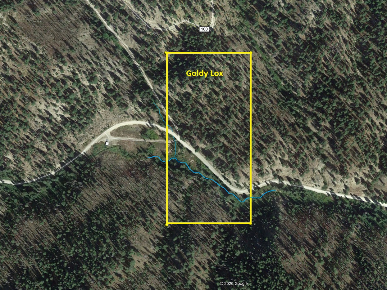
Wide West Bundle (sold)
Wide Placers
- Acreage: 10 acre unpatented placer claim
- River footage: 550’ Wide West Gulch
- Location: Elmore County, Township 4N, Range 10E, Sec. 19, NE ¼
- Mining claim serial #: IMC231978
Map to Claim
Coordinates
Marker Degrees, Minutes, Seconds
NW 43°40’24.3840”N, -115°18’13.5000”W
NE 43°40’24.3840”N, -115°18’05.9040”W
SE 43°40’18.3720”N, -115°18’05.9040”W
SW 43°40’18.3720”N, -115°18’13.5000”W
Marker Latitude/Longitude
NW 43.67344’N, -115.30375’W
NE 43.67344’N, -115.30164’W
SE 43.67177’N, -115.30164’W
SW 43.67177’N, -115.30375’W
Aerial & Topo Images
Images
From Featherville, head north on the NF 156 (about 2.7 before Rocky Bar), turn left (northwest) on NF 104 (which follows along Wide West Gulch), the claim starts at about 1 mile.
Gone West
- Acreage: 12.5 acre unpatented placer claim
- River footage: 1000’ Wide West Gulch
- Location: Elmore County, Township 4N, Range 10E, Sec. 20, NW & NE ¼s
- Mining claim serial #: IMC231975
Map to Claim
Coordinates
Marker Degrees, Minutes, Seconds
NW 43°40’08.2200”N, -115°17’41.0280”W
NE 43°40’08.2200”N, -115°17’28.6440”W
SE 43°40’01.3080”N, -115°17’28.6440”W
SW 43°40’01.3080”N, -115°17’41.0280”W
Marker Latitude/Longitude
NW 43.66895’N, -115.29473’W
NE 43.66895’N, -115.29129’W
SE 43.66703’N, -115.29129’W
SW 43.66703’N, -115.29473’W
Aerial & Topo Images
Images
From Featherville, head north on the NF 156 (about 2.7 before Rocky Bar), turn left (northwest) on NF 104 (which follows along Wide West Gulch), the claim starts at about 0.3 of a mile.
Wild West
- Acreage: 17.35 acre unpatented placer claim
- River footage: 1300’ Wide West Gulch
- Location: Elmore County, Township 4N, Range 10E, Sec. 20, NW ¼
- Mining claim serial #: IMC231976
Map to Claim
Coordinates
Marker Degrees, Minutes, Seconds
NW 43°40’14.2680”N, -115°17’56.6520”W
NE 43°40’10.4880”N, -115°17’41.9640”W
SE 43°40’07.5720”N, -115°17’41.0280”W
SW 43°40’07.5720”N, -115°17’56.6520”
Marker Latitude/Longitude
NW 43.67063’N, -115.29907’W
NE 43.66958’N, -115.29499’W
SE 43.66877’N, -115.29499’W
SW 43.66877’N, -115.29907’W
Aerial & Topo Images
Images
From Featherville, head north on the NF 156 (about 2.7 before Rocky Bar), turn left (northwest) on NF 104 (which follows along Wide West Gulch), the claim starts at about 0.5 of a mile.
Western Color
- Acreage: 20 acre unpatented placer claim
- River footage: 1150’ Wide West Gulch
- Location: Elmore County, Township 4N, Range 10E, Sec. 20, NW ¼
- Mining claim serial #: IMC231977
Map to Claim
Coordinates
Marker Degrees, Minutes, Seconds
NW 43°40’21.3240”N, -115°18’05.9040”W
NE 43°40’21.3240”N, -115°17’56.6520”W
SE 43°40’07.5720”N, -115°17’56.6520”W
SW 43°40’07.5720”N, -115°18’05.9040”W
Marker Latitude/Longitude
NW 43.67259’N, -115.30164’W
NE 43.67259’N, -115.29907’W
SE 43.66877’N, -115.29907’W
SW 43.66877’N, -115.30164’W
Aerial & Topo Images
Images
From Featherville, head north on the NF 156 (about 2.7 before Rocky Bar), turn left (northwest) on NF 104 (which follows along Wide West Gulch), the claim starts at about 0.8 of a mile.
Steel Paradise
- Acreage: 19.39 acre unpatented placer claim
- River footage: 850’ Steel Creek, Blake Gulch & 750’ gold bearing tributary (1 camping area at gate)
- Location: Elmore County, Township 4N, Range 10E, Sec. 08, SE ¼
- Mining claim serial #: IMC231973
Map to Claim
Coordinates
Marker Degrees, Minutes, Seconds
1 43°41’41.7840”N, -115°17’26.1960”W
2 43°41’43.4400”N, -115°17’18.4920”W
3 43°41’41.3160”N, -115°17’12.1560”W
4 43°41’35.7360”N, -115°17’12.1560”W
5 43°41’33.6120”N, -115°17’26.1960”W
Marker Latitude/Longitude
1 43.69494’N, -115.29061’W
2 43.69540’N, -115.28847’W
3 43.69481’N, -115.28671’W
4 43.69326’N, -115.28671’W
5 43.69267’N, -115.29061’W
Aerial & Topo Images
Images
** From Rocky Bar, turn right (north) on NF 126 (toward Atlanta). At approximately 0.3 of a mile turn right (northeast). At this location you are “on” the Steel Paradise mining claim. Immediately you will come to gate, the claim extends about 700’ past the gate along with 850’ up Steel Creek (up NF 126). Key will be provided.
Goldy Lox
- Acreage: 20 acre unpatented placer claim
- River footage: 850’ of Bear Creek + small portion of Charcoal Gulch (camping on the west side of claim)
- Location: Elmore County, Township 4N, Range 10E, Sec. 07, SW ¼
- Mining claim serial #: IMC231969
Map to Claim
Coordinates
Marker Degrees, Minutes, Seconds
NW 43°41’45.6720”N, -115°18’59.9760”W
NE 43°41’45.6720”N, -115°18’51.1920”W
SE 43°41’32.7120”N, -115°18’51.1920”W
SW 43°41’32.7120”N, -115°18’59.9760”W
Marker Latitude/Longitude
NW 43.69602’N, -115.31666’W
NE 43.69602’N, -115.31422’W
SE 43.69242’N, -115.31422’W
SW 43.69242’N, -115.31666’W
Aerial & Topo Images
Images
Driving Directions
** From Rocky Bar, continue forward on NF 156 for approximately 1.3 miles until you reach the mining claim. Along the road, on the far west side of the mining claim you will see both NF 100 road to the right, and on the left a large flat open grassy field (old Rocky Bar Guard Station) where you can camp (there aren’t any restrictions using this area to set up camp adjacent to the claim).
This claim is positioned about a ¼ mile downstream (closer to Rocky Bar) from the Dig Lots GPAA mining claim. Charcoal Gulch is a good gold bearing tributary (with additional mining claims…see below)
Crazy Bear
- Acreage: 3.18 acre unpatented placer claim
- River footage: 700’ of Bear Creek
- Location: Elmore County, Township 4N, Range 10E, Sec. 08, SW ¼
- Mining claim serial #: IMC231966
Map to Claim
Coordinates
Marker Degrees, Minutes, Seconds
1 43°41’30.4800”N, -115°17’54.6360”W
2 43°41’26.9160”N, -115°17’52.4760”W
3 43°41’27.3480”N, -115°18’04.3560”W
Marker Latitude/Longitude
1 43.69180’N, -115.29851’W
2 43.69081’N, -115.29791’W
3 43.69093’N, -115.30121’W
Aerial & Topo Images
Images
** From Rocky Bar, continue forward on NF 156 for approximately 0.6 of a mile until you reach the mining claim.
While this mining claim may only be 3 acres, it still has a good portion of Bear Cr drainage to be worked…and did you notice the picture with the exposed bedrock??? Which happens to be partially exposed all the way across the creek…great for crevice sniping (which we didn’t disturb to give the buyer an excellent adventure…*hint, may want to explore adjacent but downstream of this)!!! :o) I would also note, the Vishnu lode mine on the north (right hand side of the road from Rocky Bar) from the Crazy Bear claim, is just a standard lode mining claim “on” forest service land, so do not be intimidated by the illegally placed “private property” or “no trespassing” signs on the right side of the road. Only “mill site” mining claims on federal lands can have these signs. So, you are allowed to use this Vishnu access road to pull out, park and even camp at this location. (also see State Law Idaho Code § 47-901).
Gold Streak
- Acreage: 15 acre unpatented placer claim
- River footage: 1200’ of Bear Creek
- Location: Elmore County, Township 4N, Range 10E, Sec. 07, SE ¼
- Mining claim serial #: IMC231967
Map to Claim
Coordinates
Marker Degrees, Minutes, Seconds
NW 43°41’35.6280”N, -115°18’42.2280”W
NE 43°41’34.7280”N, -115°18’32.0400”W
SE 43°41’28.0320”N, -115°18’25.5240”W
SW 43°41’29.4720”N, -115°18’42.2280”W
Marker Latitude/Longitude
NW 43.69323’N, -115.31173’W
NE 43.69298’N, -115.30890’W
SE 43.69112’N, -115.30709’W
SW 43.69152’N, -115.31173’W
Aerial & Topo Images
Images
** From Rocky Bar, continue forward on NF 156 for approximately 1.1 miles until you reach the mining claim.
While this mining claim may only be 15 acres, when compared to all of the other mining claims we have had available on the historic gold bearing Bear Creek drainage, it offers the most creek (and deposit) area to be worked. I would also note, that its unusual shape is due to the surrounding patented (private) lode (hardrock gold veins) which are located on the east and south boundaries to this claim. The patented claim to the east, from reviewing the geological data and structure of this vein, shows that the lode (vein structure) should cut across almost the full length of this placer claim, which can be exposed and further exploration and discovery to expand more into hardrock mining through prospecting the placers on Bear Creek. I would also point out that through testing, the unnamed drainage that flows into this claim from the north which was found to also be gold bearing, from the various vein structures and significant gold deposits coming off of that smaller tributary, it adds to the amount of deposit that can be recovered on this claim.
Hidey Hole
- Acreage: 10.3 acre unpatented placer claim
- River footage: 575’ of Bear Creek (1 camping area off road)
- Location: Elmore County, Township 4N, Range 10E, Sec. 08, SW ¼
- Mining claim serial #: IMC231965
Map to Claim
Coordinates
Marker Degrees, Minutes, Seconds
1 43°41’31.3080”N, -115°17’35.7720”W
2 43°41’23.2800”N, -115°17’33.9360”W
3 43°41’29.4360”N, -115°17’42.7560”W
Marker Latitude/Longitude
1 43.69203’N, -115.29327’W
2 43.68980’N, -115.29276’W
3 43.69151’N, -115.29521’W
Aerial & Topo Images
Images
** From Rocky Bar, continue forward on NF 156 for approximately 0.25 of a mile until you reach the mining claim.
This claim is literally within eyesight of the historic mining town of Rocky Bar on the historic gold bearing Bear Creek drainage. The topo map (outlined in blue) is the “actual” placement of this claim, and its weird shape is due to the surrounding patented (private) lode (hardrock gold veins) surrounding this claim on all sides. The orange outline from the topo or boundaries from the aerial image is only the calculated triangulated location which encompasses “on” the creek, but this claim does extend up the hills (within the boundaries of the blue topo map). This claim has a good portion of Bear Cr drainage to be worked…and did you notice the picture with a great area to pull off and camp “on” the claim?
Heart O Gold
- Acreage: 20 acre unpatented placer claim
- River footage: 1400’ Bear Cr. tributary
- Location: Elmore County, Township 4N, Range 10E, Sec. 07, NW ¼
- Mining claim serial #: IMC231972
Map to Claim
Coordinates
Marker Degrees, Minutes, Seconds
NW 43°41’58.6320”N, -115°18’59.9760”W
NE 43°41’58.6320”N, -115°18’51.1920”W
SE 43°41’45.6720”N, -115°18’51.1920”W
SW 43°41’45.6720”N, -115°18’59.9760”W
Marker Latitude/Longitude
NW 43.69962’N, -115.31666’W
NE 43.69962’N, -115.31422’W
SE 43.69602’N, -115.31422’W
SW 43.69602’N, -115.31666’W
Aerial & Topo Images
Images
** From Rocky Bar, continue forward on NF 156 for approximately 1.5 miles. Turn right (north) on NF 100 road. Travel down NF 100 for approximately 2.3 miles until you reach the claim. The NF 100 road does cross this unnamed creek further north of claim, which is also found to be gold bearing.
This mining claim is a full 20 acre mining claim with 1400’ of tributary that crosses it. I will point out, that this claim is “on” a tributary where several of the Rocky Bar vein structures (which extend east to west) cross. Which means that this drainage cut through several of those veins and deposited gold within this tributary. From just simple panning (roughly a few quarts worth of material), we not only found several colors per pan, but also found many picker size pieces of gold. Further analysis and inspection of this area revealed to us that “some” old hand workings were found on the lower portion of this tributary (within about 250’ of Bear Creek) below this claim, but these upper portions of this drainage had little evidence of any extensive old mining activity. The irony is, with gold (or other precious metals), the closer to the “source” like this claim resides, the larger and high quantities of gold that is recovered. My mining partner and I are a bit hesitant & reluctant to “offer” this claim for sale, only as it does show extremely good values from the simple prospecting methods that we conducted. The NF 100 road does run parallel with this drainage (about 100’ from the drainage) for the duration of this mining claim, and up higher, this creek does physically “cross” the NF 100 road, however higher up (past the claim), there wasn’t sufficient seasonal water to conduct panning samples of the material.
Chargold Find
- Acreage: 17.69 acre unpatented placer claim
- River footage: 1050’ Charcoal Creek (1 camping area on south end of claim)
- Location: Elmore County, Township 4N, Range 10E, Sec. 07, NW & SW ¼s
- Mining claim serial #: IMC231970
Map to Claim
Coordinates
Marker Degrees, Minutes, Seconds
NW 43°41’51.7200”N, -115°19’07.9320”W
NE 43°41’51.7200”N, -115°18’59.9760”W
SE 43°41’39.8760”N, -115°18’59.9760”W
SW 43°41’39.8760”N, -115°19’07.9320”W
Marker Latitude/Longitude
NW 43.69770’N, -115.31887’W
NE 43.69770’N, -115.31666’W
SE 43.69441’N, -115.31666’W
SW 43.69441’N, -115.31887’W
Aerial & Topo Images
Images
** From Rocky Bar, continue forward on NF 156 for approximately 1.5 miles. Turn right (north) on NF 100 road. The mining claim starts almost immediately or about 150’ from NF 156. Also if you continue on NF 156, you will see that the road curves and crosses the Chargold Find mining claim, there is a wide flat area on the right (north) side of the road “on” the mining claim, suitable to camp (see pictures).
If I were to “guess”, I would say that this drainage got its name as the material does have a lot higher black sands in the concentrates, considerably more than anywhere else we tested around Rocky Bar.
Chargold Nugget
- Acreage: 17.67 acre unpatented placer claim
- River footage: 1300’ Charcoal Creek (1 camping area at switchback on claim)
- Location: Elmore County, Township 4N, Range 10E, Sec. 07, NW ¼
- Mining claim serial #: IMC231971
Map to Claim
Coordinates
Marker Degrees, Minutes, Seconds
NW 43°41’58.6320”N, -115°19’15.8880”W
NE 43°41’58.6320”N, -115°19’07.9320”W
SE 43°41’45.6720”N, -115°19’07.9320”W
SW 43°41’45.6720”N, -115°19’15.8880”W
Marker Latitude/Longitude
NW 43.69962’N, -115.32108’W
NE 43.69962’N, -115.31887’W
SE 43.69602’N, -115.31887’W
SW 43.69602’N, -115.32108’W
Aerial & Topo Images
Images
** From Rocky Bar, continue forward on NF 156 for approximately 1.5 miles. Turn right (north) on NF 100 road. Travel down NF 100 for 0.2 of a mile until you reach the claim.
The claim does extend up past the NF 100 switchback, and I will note that at this switchback is a fairly decent flat area to camp. There is also an older overgrown road that extends up the bottom of Charcoal Gulch, which is currently even accessible by atv, with a little more cutting back this would be accessible by vehicle to access back in further on the northern part of the mining claim, giving yourself a nice secluded area to work.
Upper Strike
- Acreage: 17.7 acre unpatented placer claim
- River footage: 850’ of gold bearing James Creek - Camping area on north end of claim Behind locked gate (buyer to get key)
- Location: Elmore County, Township 4N, Range 10E, Sec. 09, NW ¼
- Mining claim serial #: IMC232062
Map to Claim
Coordinates
Marker Degrees, Minutes, Seconds
1 43°42’11.5200”N, -115°16’44.7960”W
2 43°42’11.5200”N, -115°16’32.3040”W
3 43°42’05.6520”N, -115°16’35.3640”W
4 43°42’03.3120”N, -115°16’41.5560”W
5 43°42’06.8040”N, -115°16’44.7960”W
Marker Latitude/Longitude
1 43.70320’N, -115.27911’W
2 43.70320’N, -115.27564’W
3 43.70157’N, -115.27649’W
4 43.70092’N, -115.27821’W
5 43.70189’N, -115.27911’W
Aerial & Topo Images
Images
** From Rocky Bar, turn right (north) on NF 126 (toward Atlanta). At approximately 0.3 of a mile turn right (northeast). Immediately you will come to gate (buyer will receive key). Gate was installed during the old Mountain Goat mill. I own the mine “at” this gate. Continue for 0.8 of a mile until you reach the mining claim.
This mining claim is an irregular shape, as it has lode mines on virtually every side of this claim. I have even found two old adits “on” this claim. Between having its own private keyed access, to keep the typical riffraff out, and with this mining claim situated right in the middle of some of the major mines of Rocky Bar, along with camping, a site with these features is a rare find.
Between the gate and the Upper Strike mining claim is the old Laura Jackson mill and mine shaft, which is located on a patented mine, so be respectful of private property (do not get off the road to snoop around). Please lock the gate behind you (going in & out).
Sleepy Bear
- Acreage: 20 acre unpatented placer claim
- River footage: 800’ of Bear Creek & 1200’ gold bearing tributary
- Location: Elmore County, Township 4N, Range 10E, Sec. 07, SW ¼
- Mining claim serial #: IMC231968
Map to Claim
Coordinates
Marker Degrees, Minutes, Seconds
NW 43°41’45.6720”N, -115°18’51.1920”W
NE 43°41’45.6720”N, -115°18’42.2280”W
SE 43°41’32.7120”N, -115°18’42.2280”W
SW 43°41’32.7120”N, -115°18’51.1920”W
Marker Latitude/Longitude
NW 43.69602’N, -115.31422’W
NE 43.69602’N, -115.31173’W
SE 43.69242’N, -115.31173’W
SW 43.69242’N, -115.31422’W
Aerial & Topo Images
Images
Driving Directions
** From Rocky Bar, continue forward on NF 156 for approximately miles until you reach the mining claim.
This claim is positioned about a ½ mile downstream (closer to Rocky Bar) from the Dig Lots GPAA mining claim. This unnamed tributary to the north, is a good gold bearing tributary (Heart O Gold mining claim upstream).
Show me the Gold
Driving Directions (All claims)
To locate these claims, it is pavement for all but the last 8 to 9 miles, with well graded roads to access the claims.
Driving Directions from Mountain Home to Rocky Bar: Take HWY 20 (from I-84 Exit 95), north out of Mountain Home for 31.5 miles. Turn left (north) onto NF 61 (AKA Pine-Featherville Rd, signs for Anderson Ranch) and stay on this road for 28.6 miles. I will note that in Pine at the T looking intersection (at 18 miles), the main road (without stop sign), veers to the right by the Pine diner…so just stay on the main road. As you enter the original older town of Featherville (at approximately 28.6 miles from HWY 20), you will make a left (north) onto the well graded dirt road NF 156 (sign for Rocky Bar). You will continue on this for approximately 7.7 miles, until you reach the small ghost mining town of Rocky Bar. At Rocky Bar is a T intersection, where you can either continue forward in NF 156 along Bear Cr. or turn right (north) onto NF 126 (road to Atlanta). ** From Rocky Bar, additional notes will be written below the mining claim description, for access going from Rocky Bar to the claim. Signs have been placed along the roads marking out the boundaries (north/south or east/west edges) along the road.
I would also note: HWY 20 can also be reached heading north on HWY 75 (from I-84) out of Twin Falls, junction is close to Magic Reservoir or on HWY 45 (from I-84) out of Wendell if you are coming from southeast Idaho area.