Mores Creek
Grimes Creek Sold
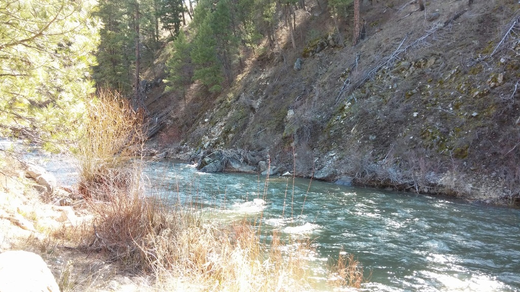
Overview
These Mores Creek claims are just a short 30 minute drive from Boise. It is well known the gold history of Mores Creek (considering all of the bucket dredging upstream by Idaho City), but these claims are situated just downstream from the Grimes Creek (also a historically well-known gold bearing tributary) confluence, which means these sites have a collection of material from both of these well-known historic tributaries. See the individual prices listed below or also see the bundle options that we have as well. These claims also have the day use parking at the junction (with bathroom facilities) or camping areas around the junction as well. With it being lower elevation, this area becomes accessible very early in the season. These claims are about a 15 minute drive from Idaho City and with it being Mores Creek it is open to suction dredging. Priced right to move them fast, so don’t miss out.
Mores #1 & Mores #2 bundle price of $2,500


Mores #1
Sold
- Acreage: 20 acre unpatented placer claim
- River footage: 700’ of Mores Creek
- Location: Boise County, Township 5N, Range 4E, Sec. 34 SE ¼
- Mining claim serial #: ID105816948
Map to Claim
Coordinates
Marker Degrees, Minutes, Seconds
NW 43°43’13.8360″N, -115°57’34.7760”W
NE 43°43’13.8360″N, -115°57’16.8840”W
SE 43°43’07.2480″N, -115°57’16.8840”W
SW 43°43’07.2480″N, -115°57’34.7760”W
Marker Latitude & Longitude
NW 43.72051°N, -115.95966°W
NE 43.72051°N, -115.95469°W
SE 43.71868°N, -115.95469°W
SW 43.71868°N, -115.95966°W
Mores #2
Sold
- Acreage: 20 acre unpatented placer claim
- River footage: 650’ of Mores Creek
- Location: Boise County, Township 5N, Range 4E, Sec. 34 SE ¼
- Mining claim serial #: ID105816949
Map to Claim
Coordinates
Marker Degrees, Minutes, Seconds
NW 43°43’20.4240″N, -115°57’34.7760”W
NE 43°43’20.4240″N, -115°57’16.8840”W
SE 43°43’13.8360″N, -115°57’16.8840”W
SW 43°43’13.8360″N, -115°57’34.7760”W
Marker Latitude & Longitude
NW 43.72234°N, -115.95966°W
NE 43.72234°N, -115.95469°W
SE 43.72051°N, -115.95469°W
SW 43.72051°N, -115.95966°W
Mores #1 and Mores #2 Gallery


Mores #3
Sold
- Acreage: 20 acre unpatented placer claim
- River footage: 700’ of Mores Creek
- Location: Boise County, Township 5N, Range 4E, Sec. 34 SE ¼
- Mining claim serial #: ID105816950
Map to Claim
Coordinates
Marker Degrees, Minutes, Seconds
NW 43°43’27.0120″N, -115°57’34.7760”W
NE 43°43’27.0120″N, -115°57’16.8840”W
SE 43°43’20.4240″N, -115°57’16.8840”W
SW 43°43’20.4240″N, -115°57’34.7760”W
Marker Latitude & Longitude
NW 43.72417°N, -115.95966°W
NE 43.72417°N, -115.95469°W
SE 43.72234°N, -115.95469°W
SW 43.72234°N, -115.95966°W
Mores #4
Sold
- Acreage: 20 acre unpatented placer claim
- River footage: 450’ of Mores Creek
- Location: Boise County, Township 5N, Range 4E, Sec. 34 SE ¼
- Mining claim serial #: ID105816951
Map to Claim
Coordinates
Marker Degrees, Minutes, Seconds
NW 43°43’33.6000″N, -115°57’34.7760”W
NE 43°43’33.6000″N, -115°57’16.8840”W
SE 43°43’27.0120″N, -115°57’16.8840”W
SW 43°43’27.0120″N, -115°57’34.7760”W
Marker Latitude & Longitude
NW 43.72600°N, -115.95966°W
NE 43.72600°N, -115.95469°W
SE 43.72417°N, -115.95469°W
SW 43.72417°N, -115.95966°W
Mores Color, Mores Karats & Mores Riches bundle of $7,000


Mores Color
Sold
- Acreage: 20 acre unpatented placer claim
- River footage: 1350’ Mores Creek
- Location: Boise County, Township 4N, Range 4E, Sec. 02, NW ¼
- Mining claim serial #: ID105762145
Map to Claim
Coordinates
Marker Latitude & Longitude
NW 43.71603’N, -115.95138’W
NE 43.71603’N, -115.94881’W
SE 43.71250’N, -115.94881’W
SW 43.71250’N, -115.95138’W
Marker Degrees, Minutes, Seconds
NW 43°42’57.7080″N, -115°57’04.9680″W
NE 43°42’57.7080″N, -115°56’55.7160″W
SE 43°42’45.0000″N, -115°56’55.7160″W
SW 43°42’45.0000″N, -115°57’04.9680″W
Mores Karats
Sold
- Acreage: 10 acre unpatented placer claim
- River footage: 700’ Mores Creek
- Location: Boise County, Township 4N, Range 4E, Sec. 02, SW ¼
- Mining claim serial #: ID105762146
Map to Claim
Coordinates
Marker Latitude & Longitude
NW 43.71250’N, -115.95138’W
NE 43.71250’N, -115.94881’W
SE 43.71060’N, -115.94881’W
SW 43.71060’N, -115.95138’W
Marker Degrees, Minutes, Seconds
NW 43°42’45.0000″N, -115°57’04.9680″W
NE 43°42’45.0000″N, -115°56’55.7160″W
SE 43°42’38.1600″N, -115°56’55.7160″W
SW 43°42’38.1600″N, -115°57’04.9680″W
Mores Riches
Sold
- Acreage: 20 acre unpatented placer claim
- River footage: 1250’ Granite Creek
- Location: Boise County, Township 4N, Range 4E, Sec. 02, SW ¼
- Mining claim serial #: ID105762147
Map to Claim
Coordinates
Marker Latitude & Longitude
NW 43.71060’N, -115.95138’W
NE 43.71060’N, -115.94881’W
SE 43.70700’N, -115.94881’W
SW 43.70700’N, -115.95138’W
Marker Degrees, Minutes, Seconds
NW 43°42’38.1600″N, -115°57’04.9680″W
NE 43°42’38.1600″N, -115°56’55.7160″W
SE 43°42’25.2000″N, -115°56’55.7160″W
SW 43°42’25.2000″N, -115°57’04.9680″W
Mores Color, Mores Karats & Mores Riches Gallery


Driving Directions from I-84 in Boise: Take the Idaho City Exit 57 and turn left onto HWY 21. Stay on HWY 21 for approximately 32.2 miles until your reach the claims. At the Grimes Creek Junction this is just past the mining claims. The Mores Color, Mores Karats & Mores Riches mining claims are situated 1.0 miles downstream from the Grimes Junction. Idaho City (with full services) is located another 9.5 miles further up HWY 21.
