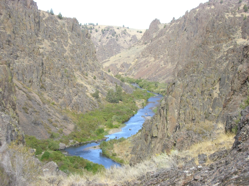
Jordan Creek Claims
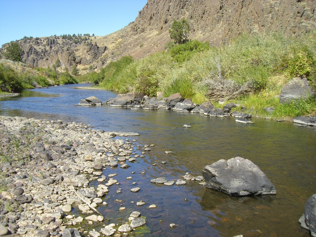
I am asked often if I have any mining claims located on Jordan Creek. With the well known history of the gold from Silver City, and the ease it is to work BLM mining claims, these types of claims are highly sought after. These mining claims are located within the canyon, which is narrower and a bit more remote. It isn’t for the faint of heart, as there is not a road that crosses the mining claims, and some hiking is required…although with the remote nature of the claims, there is some comfort in the peaceful serenity, and area that hasn’t been worked as readily. Accessing these sites would be from Jordan Valley, see the driving directions below. This area is accessible in early spring when other areas tend to still be snowed in, as they are lower in elevation. While many look at Jordan Creek for the rich deposits from the Silver City and De Lamar operations, this lower portion also has collections from the Flint mining district and South Mountain as well. The IDWR does call Jordan Creek open for dredging year round. While the claims have ample river on the claims, with great returns, due to the more remote nature of the claims, I have these priced lower than a “normal” dredging claim, to account for access.
Maps


Images


Overview
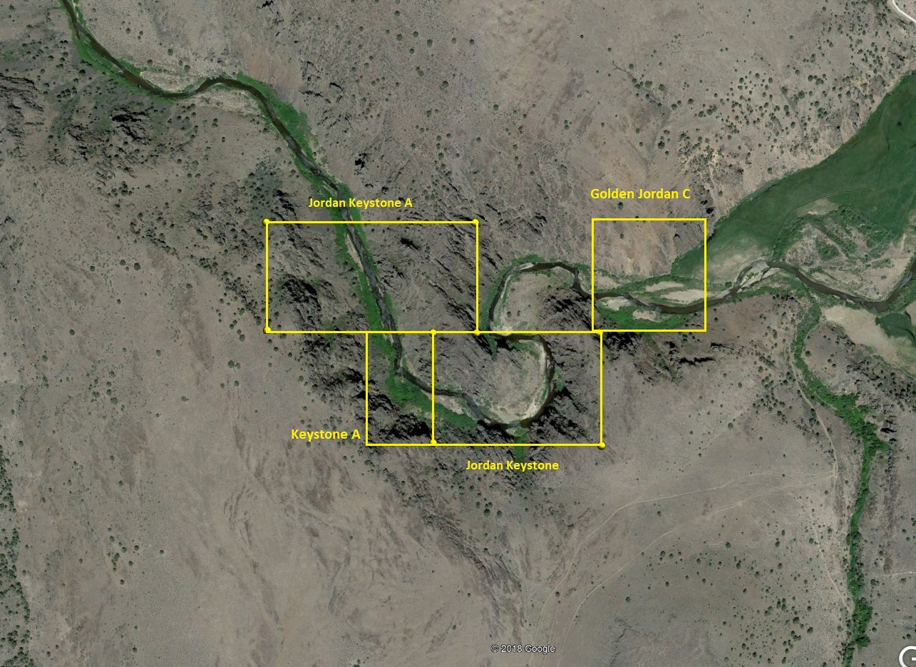
Golden Jordan C
Sold
- Acreage: 10 acres
- River footage: 660’ Jordan Creek
- Placer/lode: Placer
- Unpatented/patented: unpatented
- Location: Owyhee County, Township 6S, Range 5W, Section 26 NE 1/4
- Mining claim serial #: IMC 217213
Map to Claim
Coordinates
NW 42°52’25.7400”N, -116°53’42.6600”W
NE 42°52’25.7400”N, -116°53’33.6000”W
SE 42°52’18.9600”N, -116°53’33.6000”W
SW 42°52’18.9600”N, -116°53’42.6600”W
NW 42.8738167°N, -116.8951833°W
NE 42.8738167°N, -116.8926667°W
SE 42.8719333°N, -116.8926667°W
SW 42.8719333°N, -116.8951833°W
Aerial & Topo Images
Keystone A
Sold
- Acreage: 5 acres
- River footage: 550’ Jordan Creek
- Placer/lode: Placer
- Unpatented/patented: unpatented
- Location: Owyhee County, Township 6S, Range 5W, Section 26 SW 1/4
- Mining claim serial #: IMC 217304
Map to Claim
Coordinates
NW 42°52’19.1390”N, -116°54’00.9000”W
NE 42°52’19.1390”N, -116°53’55.6080”W
SE 42°52’12.6840”N, -116°53’55.6080”W
SW 42°52’12.6840”N, -116°54’00.9000”W
NW 42.8719831°N, -116.9002500°W
NE 42.8719831°N, -116.8987800°W
SE 42.8701900°N, -116.8987800°W
SW 42.8701900°N, -116.9002500°W
Aerial & Topo Images
Jordan Keystone
Sold
- Acreage: 15 acres
- River footage: 1400' Jordan Creek
- Placer/lode: placer
- Unpatented/patented: unpatented
- Location: Owyhee County, Township 6S, Range 5W, Sec. 26, SE & SW ¼
- Mining claim serial #: IMC222566
Map to Claim
Coordinates
NW 42.87198’N, -116.89878’W
NE 42.87198’N, -116.89509’W
SE 42.87019’N, -116.89509’W
SW 42.87019’N, -116.89878’W
NW 42°52’19.1280″N, -116°53’55.6080″W
NE 42°52’19.1280″N, -116°53’42.3240″W
SE 42°52’12.6840″N, -116°53’42.3240″W
SW 42°52’12.6840″N, -116°53’55.6080″W
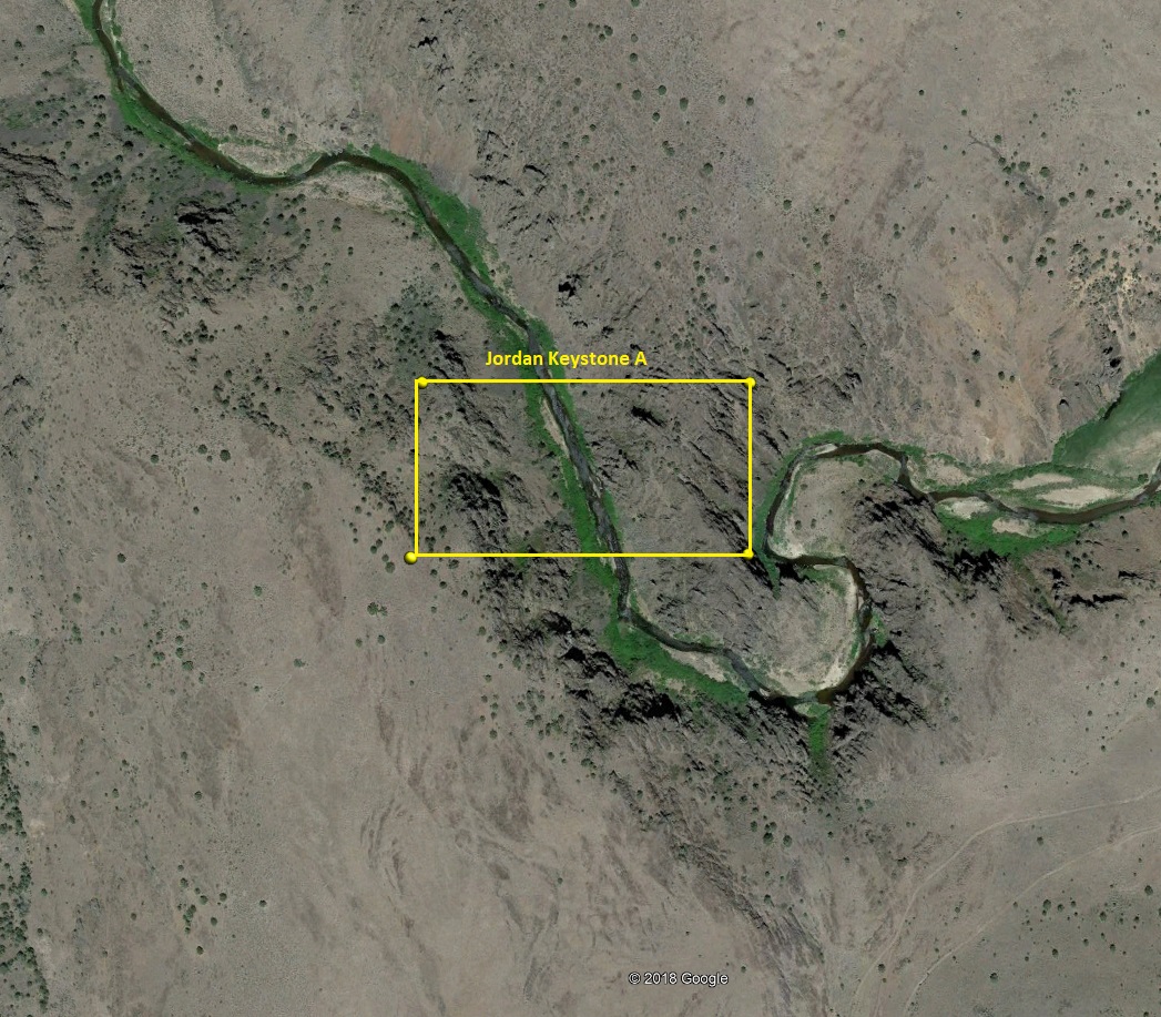
Jordan Keystone A
Sold
- Acreage: 20 acres
- River footage: 750' Jordan Creek
- Placer/lode: placer
- Unpatented/patented: unpatented
- Location: Owyhee County, Township 6S, Range 5W, Sec. 26, NW ¼
- Mining claim serial #: IMC222567
Map to Claim
Coordinates
NW 42.87374’N, -116.90238’W
NE 42.87374’N, -116.89783’W
SE 42.87198’N, -116.89783’W
SW 42.87198’N, -116.90238’W
NW 42°52’25.4640″N, -116°54’08.5680″W
NE 42°52’25.4640″N, -116°53’52.1880″W
SE 42°52’19.1280″N, -116°53’52.1880″W
SW 42°52’19.1280″N, -116°54’08.5680″W
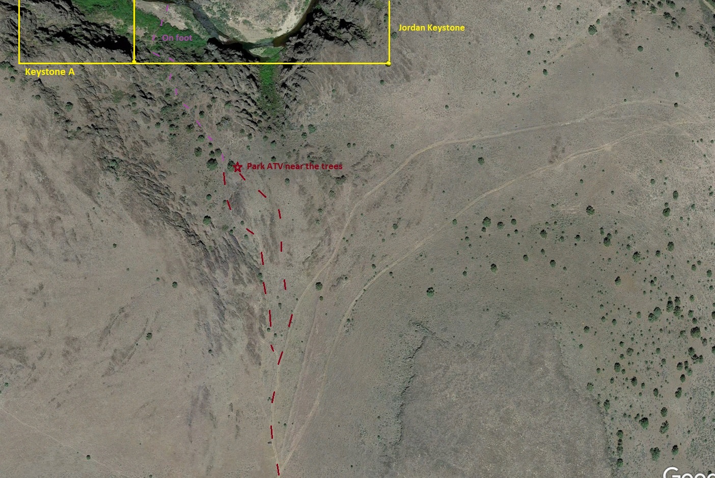
Driving Directions from Nampa: From Exit 33A in Nampa, head west on Karcher Rd (name changes to SR-55 just outside Nampa). After 16 miles, turn left (south) on US 95. You will stay on US 95 for approximately 44 miles till you reach Jordan Valley. US 95 takes an abrupt turn west in the center of town, at this turn you will turn left (east) on Yturri Blvd (name changes to Pleasant Valley Rd just outside Jordan Valley). Stay on this road for 7.5 miles, then left on South Mountain Rd. After following this for 6.1 miles, you will come to the “South Mountain Ranch”, where there will be a dirt access road (42°49’47.24″N, -116°55’43.95″W) to the left (northeast), which you will turn on. Take this for approximately ½ of a mile, where there is a flatter area to park your truck (42°49’59.57″N, -116°55’12.96″W). There are other roads & trails (roads aren’t marked in the field or labeled on any maps), so I would zoom into Google Earth and get familiar with the spots. There are also a couple gates back in further, just make sure to close the gates behind you. While I have seen people pull their camp trailers all the way to the ravine, I personally would recommend taking an atv from here. At this parking area, there is a fork, take the fork on the left, for about ¼ of a mile, at the second fork (42°50’11.56″N, -116°54’52.10″W), take the main road on the right (left fork is hardly visible). You will follow this for about a mile & half. The road will start to drop down into a greener gulch where the road crosses the season creek. Right before crossing the creek, you will turn left (42°50’19.44″N, -116°53’29.52″W). You will take this road for about 2.3 miles. There is another “Y” closer to the end (42°51’57.75″N, -116°53’47.61″W), you basically want to be following the ravine down on the left, so stay on the left Y for about 500′, and then I get off that trail and continue on the right side of the ravine for another 800′, I have driven the bottom of the ravine, or up on the right side…I like parking the ATV by the trees (42°52’09.00″N, -116°53’50.82″W)…or you can park off the road, and hoof it the rest of the way. Jordan Creek is about another 750 feet (from the trees) down the ravine (there is a prominent trail), and when you reach Jordan Creek, you will be “on” the western portion of “Jordan Keystone” mining claim which extends about another 100′ downstream and 1250′ upstream. Jordan Keystone A is about 600′ downstream. I would recommend a gps unit to help navigate.
Driving option 2: From Jordan Valley, (where you are turning east onto Yturri Blvd / Pleasant Valley Road) continue on Pleasant Valley Road for 5.8 miles (from Jordan Valley), and turn left (southeast) onto Flint Road. You will stay on Flint Road for approximately 7.8 miles, and park close to the access road (42°52’55.04″N, -116°53’41.00″W) which is gated (with a cable over the road). It is public ground by the gate & coral, so you are okay to park around that area (just don’t block the gate). From this location, you would head south (not on the access road) on foot about a ½ mile until you reach Jordan Creek. I would recommend taking the ravine (42°52’31.78″N, -116°53’36.68″W) as it is easier to hike into, and there won’t be sudden steep rock faces. There are a few off road atv tracks running through that flat open area, so you can get a little closer with an atv, just not sure it is really worth packing an atv in with such a short trip. Once hitting Jordan Creek, the Jordan Keystone claim is another ¼ of a mile downstream around the first major curve in the river.
There isn’t a whole lot of people activity back here, and with it being more deserty terrain, you will want to watch (listen) for rattle snakes.


About Jordan Creek
“About Jordan Creek”
Where does the gold in Jordan Creek come from? There are a few main sources for the gold found in Jordan Creek, closer to Silver City, you would have all the vein activity on War Eagle Mountain (could research Addle, New Year, Poorman, Empire, Illinois Central, War Eagle mines to name some of the major that feed into Jordan Cr.), the Florida Mountain Range (with Potosi, Trade Dollar/Black Jack, Tip Top, Empire State, Banner mines to name a couple), and further downstream is the De Lamar mountain, which is essentially one massive open pit mine. Closer to this lower section, you have the Flint district (with the Perseverance, Rising Star, Crescent, Silver Queen, Treasure Vault, Hornet mines to name a few), and then South Mountain activity (just a few miles to the southeast of the claims with the Texas, Golconda, Standard mines).
Show me the Gold
Gold Recovered From the Area:
http://www.idahogeology.org/PDF/Bulletins_(B)/B-11.pdf
http://www.idahogeology.org/PDF/Pamphlets_(P)/P-138.pdf
What does the color look like?
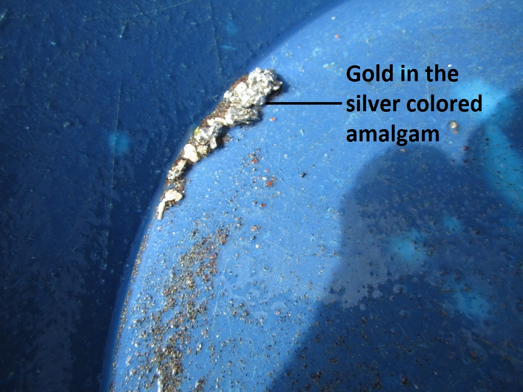
Let’s talk about the gold…I have worked Jordan Creek for over 20 years throughout various parts of it. First and foremost, is you are likely going to find amalgam (mercury with gold) in placer recovery, and you want to SAVE this, not toss it back in the creek (which I hear about inexperienced prospectors doing). More on amalgam below. Gold from this region has a high silver content, and so it is pretty common to see 18 karats. I have metal detected what I thought were silver nuggets, to later discover that they were 40% gold. In Jordan Creek, you will also find ample amounts of black sands…so get them magnets out. :o)
Where does all the mercury come from?
If you read old reports, there supposedly was a spill of 10,000 lbs of it into Jordan Creek by Silver City, plus the placer operations in the area…but the area is also known for its Cinnabar where mercury is naturally forming. So, with those high contents, I wouldn’t eat the fish. :o) You will also find a lot of black sand in your concentrates from Jordan Creek. When working in Jordan Creek, lets say dredging for example, I would recommend that you take additional steps to detox heavy metals (like the mercury) from your body. Simple things like cooking more with onions and garlic, eat more omega-3 fats.