High & Dry Commercial Op
Overview
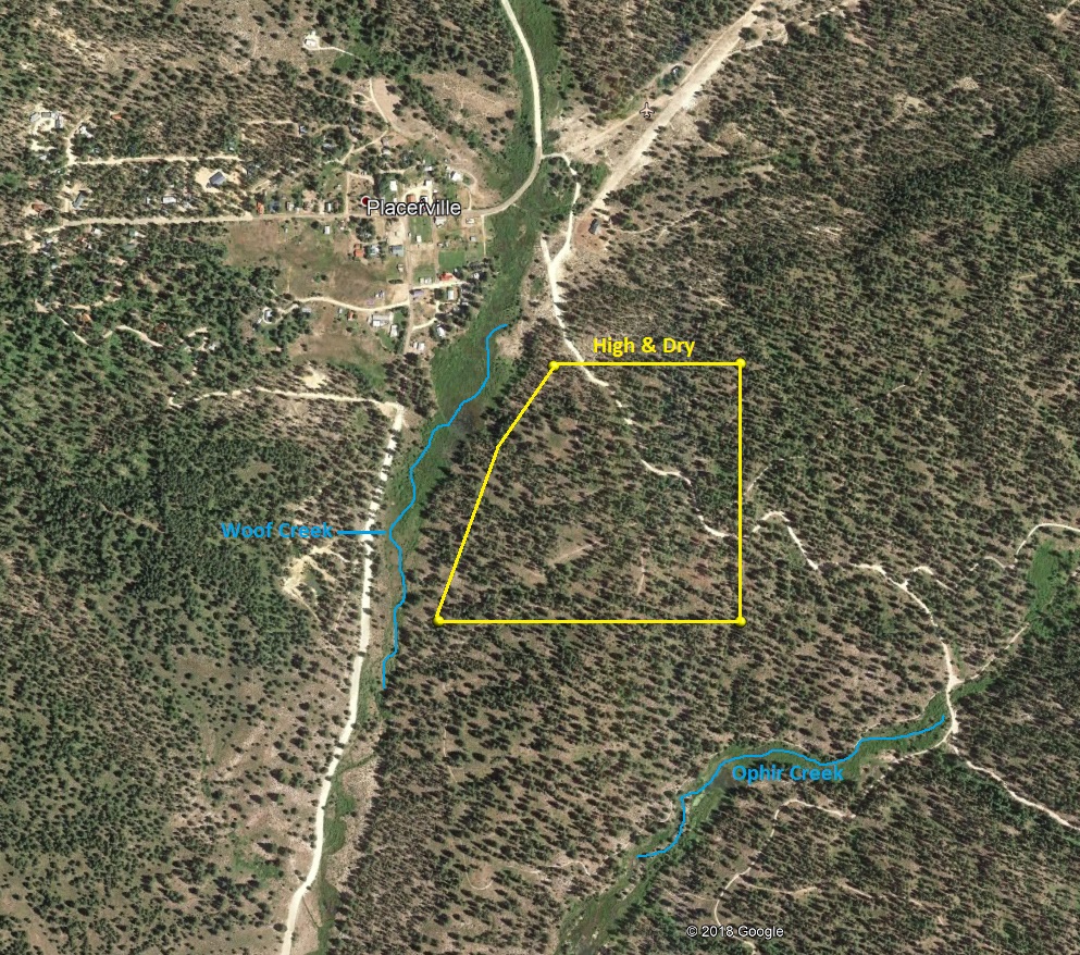
This commercial size mining operation site off Woof Creek, is 40 acres of incredible upper benches, which is blanketed with gold bearing glacial till deposit. There is evidence of some old hydraulic workings, but it is isolated to the narrower gullies on the claim, so a vast majority of the claim are roly ridge lines and hills where these virgin deposits are still waiting to be explored. An approved plan was developed for this site, with the main test area (in the far northwest part of the claim) being less than three acres, which all seemed to contain virgin glacial till. Although, the actual work site of disturbed ground (including ponds, material that was processed from the pit and access roads), during the operation was under a ¼ of an acre. Other virgin deposits have been discovered on the claim but this area was the easiest to access and setup equipment. Even at the work site, there was still a decent sized layer of virgin deposit that we left, roughly around 2 acres. There are existing BLM roads which wind around throughout the full length of the mining claim (even down to the SW & SE corners) making it extremely versatile for access & equipment staging. The topsoil overburden seemed to be around 6” to 12” thick, but again, we discovered multiple exposed areas of this glacial deposit throughout the claim, with large cobble being present even at the ridge tops, with all the pan samples collected showing decent color, but need further exploration to determine size and value.
This claim is on BLM land, who’s currently one of the easiest management agencies to work with in Idaho for mining plans. While the work site has been reclamated, it is our intention to transfer the approved plan, which is still in good standing, with the sale of this claim. The bond for the work that was approved through the plan is $2,800 (which gets paid to the BLM directly), or there is the option of doing a Surety Bond (roughly 10% the bond cost). If the approved plan is not entirely to your operational needs, plans can easily be amended through the BLM geologist (contact information will be provided). The claim itself is dry but permission was obtained from the land owners on Woof creek to pump water for our exploration project. Another option is pulling from Ophir creek (which is public, yet further), but was going to be the backup water source if we couldn’t get permission to use Woof creek.
The claim is situated between two of the largest (historic) placer mines being the Reid and Halley Placers. As well as close proximity to Quartzburg. The small and historic town of Placerville is right next door, which has a small market store as well as phone reception. Full services are available at either Idaho City or Garden Valley for restocking (fuel or groceries) just 30 minutes from the site.


“High & Dry”
Sold
- Acreage: 40 Unpatented Placer claim
- Glacier Benches of Woof Creek
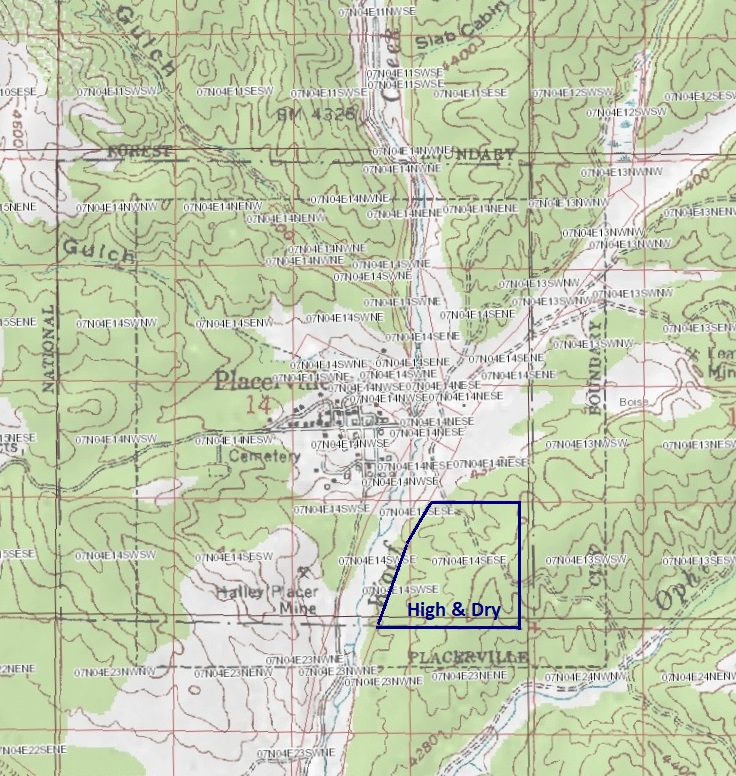
- Boise County, Township 7N, Range 4E, Section 14, SE Corner
- Mining claim serial #: IMC223283
GPS Coordinates
NW 43.94072’N, -115.94310’W
NE 43.94072’N, -115.93919’W
SE 43.93689’N, -115.93919’W
SW 43.93689’N, -115.94546’W
NW 43°56’26.5920″N, -115°56’35.1600″W
NE 43°56’26.5920″N, -115°56’21.0840″W
SE 43°56’12.8040″N, -115°56’21.0840″W
SW 43°56’12.8040″N, -115°56’43.6560″W


Show me the Gold
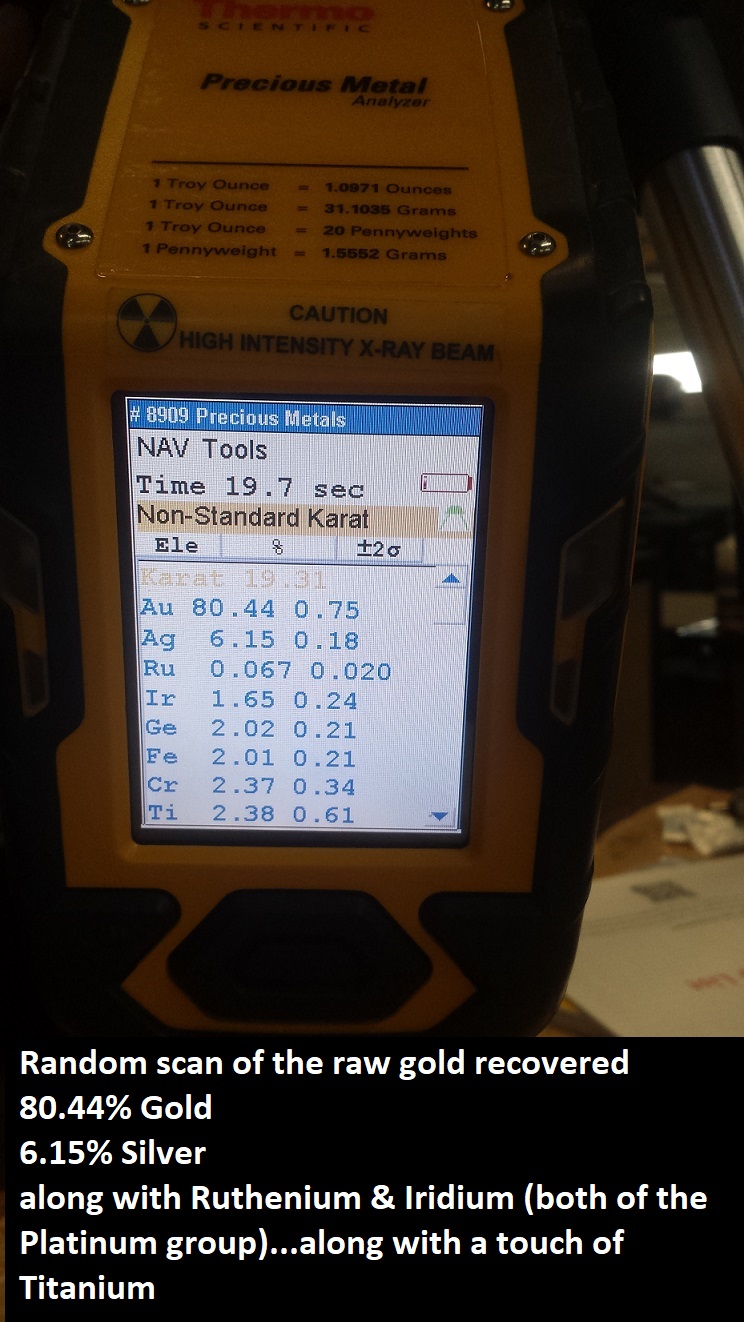
A total of 700 yards from approximately 1/8th of an acre was processed through a trommel using 6’ of gold hog mats (on the upper sluice) and angle iron riffles, and #3 expanded for the lower sluice, for the recovery. A total of 6.35 ozt of gold was recovered, mostly ranging from 50-100 mesh in size, but also a few nice pickers. Using a “Thermo Scientific Niton XL2” (for precious metals), gold purity ranged from .800 to .910 (19 to 22 karat) and PGMs were present in most of the scans (especially when melting down the remaining concentrates, after removing most of the visible gold). The material deposit (glacial till) was mainly composed of 3”-6” cobble (20%), 1”-3” gravels (30%), and 1” minus decomposed granite (50%). Clay is present and carries low values of gold. The deposit itself is 7’ thick in some areas and pinches down to 1-2’ thick in others. At the processing pits, it had an average of 5’ thickness. Bedrock is decomposing granite. When processing material we would clean out the upper box at twenty five yards and do a full clean out (both sluices) at roughly two hundred yards. For the upper box the best results achieved (after 25 yards) was 0.71 gram per yard (GPY), the lowest being 0.18 GPY, with a base average of 0.28GPY. However, this doesn’t account for remnants of gold (see scan results), as well as silver and PGMs still left behind in the concentrates. Given today’s price of gold averaging at $1500/ozt, with 85% purity, and 0.28GPY, we were processing $11-$12 per yard averages (not including additional precious metals in the cons). All of the gold was clean with no amalgam/mercury present.


Quartzburg link pg. 253
https://pubs.usgs.gov/bul/0846d/report.pdf
Placerville link pg. 1
https://www.idahogeology.org/pub/Bulletins/B-22.pdf
Driving directions: This mining claim is abutting the town of Placerville which has three main ways of getting to it; 1) Harris Creek Road (from Horseshoe Bend), 2) Centerville Road/NF-307 (from Idaho City) or 3) Alder Creek Road/NF-615 (from Garden Valley). From Boise, it takes about an hour to an hour & 15 minutes get up to this claim as you are leaving town, really just depends on which side of Boise you are leaving from.
Directions Going through Idaho City – from Boise, travel north on HWY 21 to Idaho City (approximately 34 miles from I-84). Turn left (north) onto either Montgomery St or Main St in Idaho City. In about a ¼ of a mile turn left (west) onto Centerville Road. Continue on Centerville Road (which is gravel in the middle), for about 11.5 miles, and then turn right (north) at the Placerville junction (there is also a row of mailboxes here). Travel north up NF-615 for about 1.3 miles. At the T intersection (fire station across the street) in Placerville turn right and continue following NF-615 (AKA Granite St in town). In about two blocks after the road curves, make a right onto NF-349. The road will cross the Woof Creek drainage, and just past the flat open parking area (by the two story home on the left), the claim will be immediately on the right. As you continue up the NF-349 road, the road will pass across the claim, along with two BLM roads that will head right (south) that meander through the 40 acre site.
Note:
You can google maps the other two ways in, which is pretty easy to find & on main roads, just by plotting in “Placerville”. I would caution you that google maps after plotting Boise to Placerville, on the Idaho City side, will typically select turning onto Grimes Creek Road (avoiding Idaho City completely)…if you want to add 30 minutes (longer than it says) & one bumpy @$$ adventure to your trip, you are welcome to it, but would strongly recommend going through Idaho City.


